
Central African Power Pool
Equatorial Guinea electricity grid and access
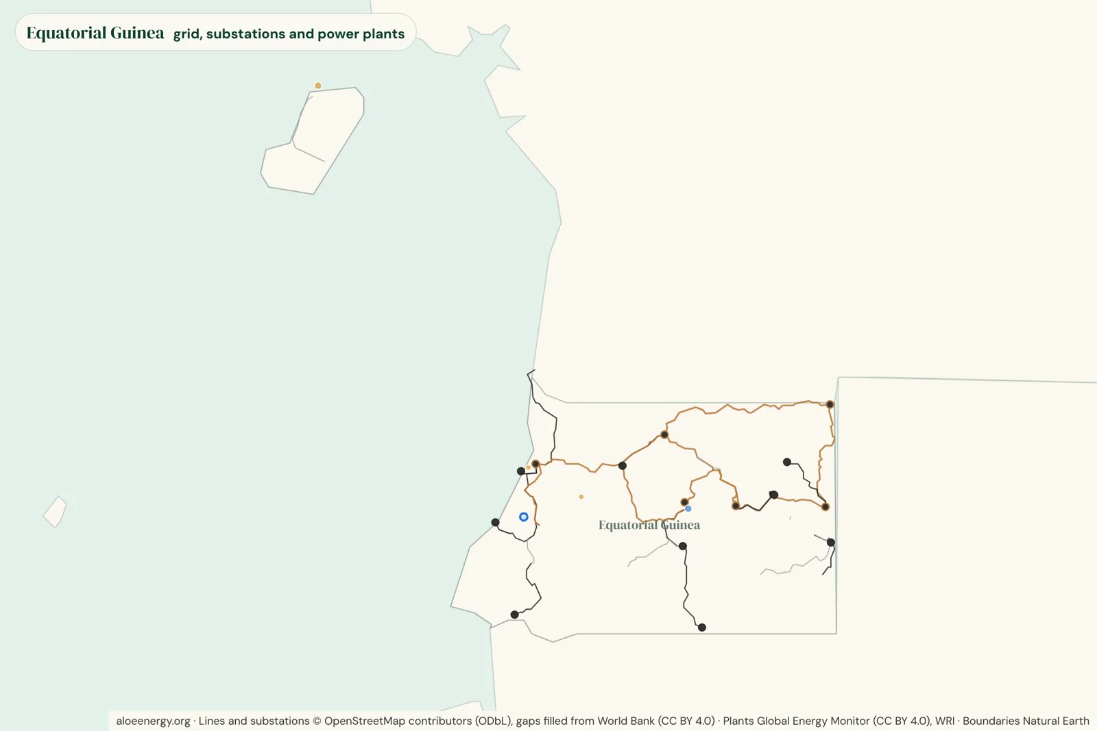
About 443,000 people in Equatorial Guinea live where satellites see no electric light at night, and 100% of them live within 15 km of a power line. This page brings together what our open atlases show for Equatorial Guinea: about 1,208 km of high-voltage lines, 338 MW of power plants and the projects still to come.
Open the live atlas for Equatorial Guinea Download the country report (PDF, 0.3 MB, November 2026) Rapport pays en français (PDF, novembre 2026) Relatório do país em português (PDF, novembro de 2026) Distribution network map
Free A2 posters of Equatorial Guinea’s grid: today and 2035 and beyond (PDF). All posters
Lines, substations and demand
Equatorial Guinea's mapped high-voltage network runs to about 1,208 km of lines at 66 kV and above, with 15 substations. The highest voltage on the map is 220 kV, and 47% of the line length runs at 220 kV or more. Installed capacity was about 343 MW (GEM Sep 2026). The latest international tracking report puts access to electricity at 65% of people.
| Voltage | km |
|---|---|
| 220 kV | 571 |
| 110 kV | 446 |
| Voltage not recorded | 191 |
| Total | 1,208 |
Who lives near the grid but off it
About 443,000 people in Equatorial Guinea, roughly 23% of the population, live where satellites see no electric light at night. Of them, 100% live within 15 km of a mapped or predicted power line: 309,000 within 2 km, 133,000 2 to 15 km away, and 0 farther out. The largest group lives within 2 km of a line, so the main gap is last-mile connections and affordability, more than new lines.
- Within 2 km: 309,000 (70%)
- 2 to 15 km: 133,000 (30%)
- More than 15 km: 0 (0%)
See the numbers as a table
| Distance | Million people | Share |
|---|---|---|
| Within 2 km of a line | 0.31 | 70% |
| 2 to 15 km | 0.13 | 30% |
| More than 15 km | 0.00 | 0% |
| Total | 0.44 | 100% |
How we count this
"Without night-time light" is a satellite proxy, not a measured access rate. Distances are straight lines to mapped or predicted lines. See the grid-edge atlas for the method.
Power plants and projects
Four operating power plants of 10 MW and above add up to about 338 MW, 64% of it gas. The largest is Malabo Turbogas power plant (154 MW, gas). Another 1 plant totaling about 200 MW is under construction or planned, 200 MW of them under construction. Most of the pipeline is hydro. The largest plant under construction is Sendje hydroelectric plant (200 MW, hydro).
One transmission project touching Equatorial Guinea is in our register.
- Cameroon - Gabon - Equatorial Guinea interconnection: feasibility, expected 2033.
| Type | Operating MW | Pipeline MW |
|---|---|---|
| Hydro | 120 | 200 |
| Gas | 218 | |
| Total | 338 | 200 |
More about Equatorial Guinea
Open any topic for the full text and tables.
Waste to WealthSecond life for solar and batteries
Between 2026 and 2040, about 204 tonnes of solar equipment and stationary batteries are expected to retire in Equatorial Guinea, most of it solar panels. That is 0.0% of the total for the 49 countries in our second-life atlas. West and Central Africa have no recycler for panels or lithium batteries yet (one is planned in Ogun State, Nigeria), only e-waste collection in Accra, Lagos and Dakar and some lead-acid smelters, so for now this waste would be shipped abroad from the nearest seaport. Reuse comes first: Spiro already puts retired swap batteries to work as storage.
| Stream | Tonnes | Share of country |
|---|---|---|
| Solar panels | 107 | 52% |
| Off-grid solar kits and mini-grids | 97 | 48% |
| Total | 204 | 100% |
| Equatorial Guinea | Atlas total | Share | |
|---|---|---|---|
| Retiring solar and batteries (tonnes) | 204 | 507,091 | 0.0% |
| Reusable battery storage (MWh) | 0 | 4,664 | 0.0% |
| Retiring in 2030 (tonnes) | 8 | ||
| Retiring in 2035 (tonnes) | 12 | ||
| Retiring in 2040 (tonnes) | 20 |
From our second-life atlas, central case, by country. Electric vehicle batteries are modeled for the region as a whole, so they are not in these country figures.
EmissionsGrid emission factor
Each megawatt-hour generated in Equatorial Guinea in 2024 came with about 0.37 tonnes of CO2. For carbon projects such as solar mini-grids, the combined margin (the usual basis for crediting) is about 0.40 tCO2/MWh. Looking ahead, our scenarios from the plants in the pipeline put the average at 0.16 tCO2/MWh in 2030 and 0.21 in 2035, depending on how many plants arrive on time (see the scenarios). We have not yet rated the quality of its data. See our grid emission factors for the method and all 49 countries.
Grid mix, 2024.
Gas 72% Oil and diesel 1% Hydro 27%
| Measure | tCO2/MWh |
|---|---|
| Generated in country | 0.371 |
| Electricity used, with imports | 0.371 |
| Combined margin (for carbon projects) | 0.404 |
Tariffs and load sheddingWhat power costs here
Our utilities, tariffs and load shedding page compares 49 African countries by customer class, with what each tariff includes and load shedding since 2015.
| Measure | Value |
|---|---|
| Load shedding now | No 2026 load shedding reports found (searched 19 Nov 2026); exports power to Gabon over the interconnector opened in Feb 2025 |
Energy charge only, at the central bank rate on 30 October 2026. Check what is included (VAT, levies, fixed charges) on the research page.
Grid consumptionWho uses the power on the grid
Households used about 41% of the country's electricity in 2023, by UN estimates. We have not found an official split by customer class yet. Our grid consumption page compares sales by customer class, power use per customer and peak demand across 49 African countries.
| Measure | Value |
|---|---|
| Households (UN) | 41% |
| Commercial and public (UN) | 22% |
| Industry (UN) | 34% |
| Agriculture and other (UN) | 2% |
| National use, UN 2023 | 873 GWh * |
UN: UN Energy Statistics Database (UNdata). * UN estimate or a single figure from a news report.
Certificates and carbon creditsRenewable energy certificates
Equatorial Guinea cannot issue I-RECs, the international renewable energy certificate, yet. No carbon credit projects are listed for it on the voluntary registries. See our certificates page to compare certificates with carbon credits across the region.
| Measure | Value |
|---|---|
| I-REC status | Not approved |
| Registered plants | - |
| I-RECs issued, all years | - |
| Carbon credit projects | 0 |
| Carbon credits issued | - |
I-RECs: Xpansiv I-REC Registry statistics, October 2026. Carbon projects: CarbonPlan OffsetsDB (Verra, Gold Standard and other voluntary registries), data to June 2026. Article 6: UNEP Copenhagen Climate Centre Article 6 Pipeline, November 2026.
Lit but off the mapWhere the lights are and the map is not
Satellites see 76 lit places in Equatorial Guinea at night. 49 are within 2 km of a mapped line, 16 are 2 to 10 km away and 11 are 10 km or more from any mapped line. Places lit far from the map point to lines the map is missing, mines and plants with their own power, or mini-grids.
The lit places off the map cover about 95 km² and are home to about 42,754 people.
| Distance | Lit places | Newly lit |
|---|---|---|
| Within 2 km of a mapped line | 49 | |
| 2 to 10 km away | 16 | 10 |
| 10 km or more | 11 | 2 |
See them on the map: the "Lit but off the map" layer of the grid-edge atlas.
Water and climate riskHydro and drought
Hydro is 36% of the operating power plants in Equatorial Guinea and made 27% of its electricity in 2024.
A dry year that takes a fifth of hydro output would cost about 10 MW on average over the year, and a severe drought (two fifths, as Zambia saw in 2024) about 20 MW.
Our data has no import line with a published capacity, so a shortfall would have to be met at home.
| Measure | Value |
|---|---|
| Hydro in operating capacity | 36% |
| Operating hydro (MW) | 123 |
| Hydro in 2024 generation | 27% |
| Dry year, average MW lost | 10 |
| Severe drought, average MW lost | 20 |
Method and all countries: hydro dependence and drought exposure.
From power plant to battery siteWhen the thermal plants close
Equatorial Guinea has 1 coal, gas or oil plant site of 50 MW or more, with 154 MW of grid connection. None of it frees up before 2030 in our central case.
Putting solar and batteries on those connections when they free up would save about 0.3 Mt of CO2 between 2026 and 2050, worth about 0.8 times what they cost to build at the US EPA's social cost of carbon.
| Plant | Fuel | Connection (MW) | Frees up | CO2 saved 2026-2050 (Mt) |
|---|---|---|---|---|
| Malabo Turbogas power plant | Gas | 154 | 2039 | 0.3 |
Timings, cases and every site: power plant to battery site.
Waste to WealthPower from waste
Equatorial Guinea's sugar mills, landfills, sewage works, factories and crop residues could make about 4 MW of power that is not built yet (central case), avoiding about 9,145 t of CO2e a year.
| Source | MW |
|---|---|
| Landfill gas and biogas | 0.4 |
| Crop and sawmill residues | 3.1 |
Every site, costs and the method: power from waste.
Second lifeWho could use a second-life panel
Places in Equatorial Guinea that could use a second-life solar panel add up to about 157 MWp (range 70 to 356): 153 MWp to cut generator use in towns, 3 MWp for mini-grids, 1 MWp for household systems and 0.1 MWp for 15 health facilities and 0 schools with no light at night.
Mapped by half-degree cell, with years to 2040: where the panels are needed.
E-mobilityElectric transport, per km
On Equatorial Guinea's grid, an electric motorbike emits about 26 g of CO2 per km from the power it charges with, against 48 g for a petrol one (46% less).
| Vehicle | Electric | Petrol or diesel | Difference |
|---|---|---|---|
| Motorbike | 26 | 48 | -46% |
| Bus | 480 | 1,673 | -71% |
| Small car (newer petrol car) | 77 | 125 | -38% |
Life-cycle figures, a cost calculator and city air: e-mobility.
Neighbors, sources and updates
Neighboring countries
More in the CAPP grid atlas, grid-edge atlas, second-life atlas and grid emission factors, or see all countries.
Sources 12 sources
- Grid lines: OpenStreetMap contributors (ODbL), with gap-fill from the World Bank Africa electricity grid (2017).
- Power plants: Global Energy Monitor, Global Integrated Power Tracker (September 2026), with WRI and curated public project sources.
- Capacity and access: national regulators and utilities, and the Tracking SDG7 Energy Progress Report 2026.
- People without night-time light and distance to the grid: WorldPop 2020 and gridfinder (Arderne et al. 2020, CC BY 4.0), as screened in our grid-edge atlas.
- Retiring solar and batteries: our second-life atlas model (central case, regular losses), from public project registers and IRENA lifetimes.
- Emission factors: our grid emission factors (Ember, 2024).
- Lit places: NASA Black Marble night lights, compared with our mapped lines (grid-edge atlas).
- Hydro and drought: our hydro exposure analysis (plants from our grid atlases; generation from Ember, corrected with regulator figures).
- Thermal plant sites: Global Energy Monitor, Global Integrated Power Tracker (September 2026), and our thermal-to-storage model.
- Power from waste: FAOSTAT, Global Energy Monitor and OpenStreetMap sites, in our waste-to-energy model.
- Second-life demand: grid-edge screening, compact targets, World Bank Enterprise Surveys and health and school facility lists, in our second-life atlas.
- Transport per km: our grid emission factors and vehicle energy use; running costs from national pump prices and tariffs.
The maps are free to view. The data behind this page is available on request: email [email protected]. Lines are indicative, not for engineering or investment decisions.
What changed 4 updates
Our data is checked every month, and this page is rebuilt after each check.
- 19 November 2026 - Latest update to the CAPP grid atlas, which this page is generated from.
- 19 November 2026 - Latest update to the grid-edge atlas, which this page is generated from.
- 19 November 2026 - Lit but off the map now covers all 43 countries (Mali, Guinea-Bissau, Cabo Verde and Equatorial Guinea added, with their OpenStreetMap lines), and people around Chad's lit places now come from the building-based layer: 20,300 places 2 km or more from a mapped line, about 106 million people. The free download is now version 2: 20,647 places in 43 countries. Road distances for Mali, Guinea-Bissau, Cabo Verde, Equatorial Guinea, Djibouti and Comoros now feed the chance bands.
- 19 November 2026 - Mali, Guinea-Bissau, Cabo Verde and Equatorial Guinea added: 43 countries. Every country now counts people from buildings: Chad moves from WorldPop to Microsoft building footprints and Mali uses Overture Maps buildings, because Google's building data has none there. Headline: 633 million people without night-time light (was 617 M), 499 million of them within 15 km of a line (was 490 M). The lit-but-off-the-map layer still covers the first 39 countries.
Common questions about Equatorial Guinea
Where can I find a map of Equatorial Guinea's electricity grid?
The free CAPP grid atlas maps Equatorial Guinea's high-voltage lines, substations, power plants of 10 MW and above and planned projects. Open it zoomed to Equatorial Guinea.
How many people in Equatorial Guinea live without electricity?
About 443,000 people live where satellites see no electric light at night, a proxy for living without power. Of them, 100% are within 15 km of a power line.
How long is Equatorial Guinea's transmission network?
About 1,208 km of mapped lines at 66 kV and above, mostly from OpenStreetMap.
How much power generation does Equatorial Guinea have?
Operating plants of 10 MW and above add up to about 338 MW in our atlas, with about 200 MW more under construction or planned.
What is the grid emission factor for Equatorial Guinea?
About 0.37 tCO2/MWh for electricity used in 2024, and 0.40 tCO2/MWh as a combined margin for carbon projects. See our grid emission factors for the method.
Can I get the data for Equatorial Guinea?
Yes, on request. The maps are free to view; email [email protected] and tell us what you need it for.
 Spotted an error, or something missing on this page? Report an issue or send feedback